Explore Centuries of Brooklyn’s History With These Newly Digitized Maps
The Brooklyn Historical Society recently launched a portal featuring almost 1,500 documents dating back to the 17th century
/https://tf-cmsv2-smithsonianmag-media.s3.amazonaws.com/accounts/headshot/nora.png)
/https://tf-cmsv2-smithsonianmag-media.s3.amazonaws.com/filer/f7/58/f7583bf6-426d-47a2-87fd-22a2d7a4ca4e/brooklyn_of_the_future.jpg)
Before Brooklyn became a New York City borough home to 2.6 million people and countless hipster coffee shops, it was better known as Breuckelen, an early 17th-century Dutch settlement surrounded by marshes and farmland. Now, anyone with an internet connection can retrace the district’s history through a newly digitized collection of maps available via the Brooklyn Historical Society’s (BHS) free online portal.
Per a statement, the trove includes almost 1,500 maps dating back to the 17th century, when Brooklyn was still an unincorporated collection of colonial towns across the river from New Amsterdam—a settlement that later became Manhattan. (Brooklyn was consolidated as a borough of New York City in 1898.)
Because of their age, many of the maps are too fragile to be handled in person.
“Maps pose unique access issues, primarily due to their size and fragility, which means that we try to minimize handling to preserve the materials in the long term,” Maggie Schreiner, the society’s manager of archives and special collections, tells Brownstoner’s Susan De Vries. “The map portal allows us to make all our maps accessible to users regardless of their location.”
/https://tf-cmsv2-smithsonianmag-media.s3.amazonaws.com/filer/16/e1/16e109a6-e5bb-46ad-8a21-fff1535c8bb6/brooklyn_map.jpg)
/https://tf-cmsv2-smithsonianmag-media.s3.amazonaws.com/filer/fe/7a/fe7aebd8-362d-4e53-ad64-d46a9f813ad5/flatbush_map.jpg)
/https://tf-cmsv2-smithsonianmag-media.s3.amazonaws.com/filer/cb/16/cb16b80c-c49a-4f58-ace1-a904174f4e8f/prospect_park.jpg)
Early entries in the database offer evidence of farming communities that persisted in Brooklyn for hundreds of years. Until the end of the 19th century, Kings County, the county coterminous with Brooklyn, was the second-largest provider of produce in the country, according to the BHS.
After its establishment by Dutch colonists in 1651, for instance, Flatbush served as a farming town for more than 250 years. Crucially, farming didn’t always mean doing the work oneself: Wealthy farmers often forced enslaved Africans to work their fields, and as the BHS notes, these individuals “were central to the growing affluence of Flatbush’s Dutch residents.”
Speaking with Caroline Spivack of Curbed New York, Shriner says, “One of the stories that’s told most dramatically through these maps is the transition of Brooklyn from an agricultural region of villages to a very dense, populous borough.”
She adds, “That’s an exciting story not just to read about in a book, but through these maps, to actually see those changes to what the physical environment looked like.”
/https://tf-cmsv2-smithsonianmag-media.s3.amazonaws.com/filer/a7/d0/a7d04d69-544b-4eef-91d3-a3df06f76b81/sickly_neighborhoods_in_bklyn.jpg)
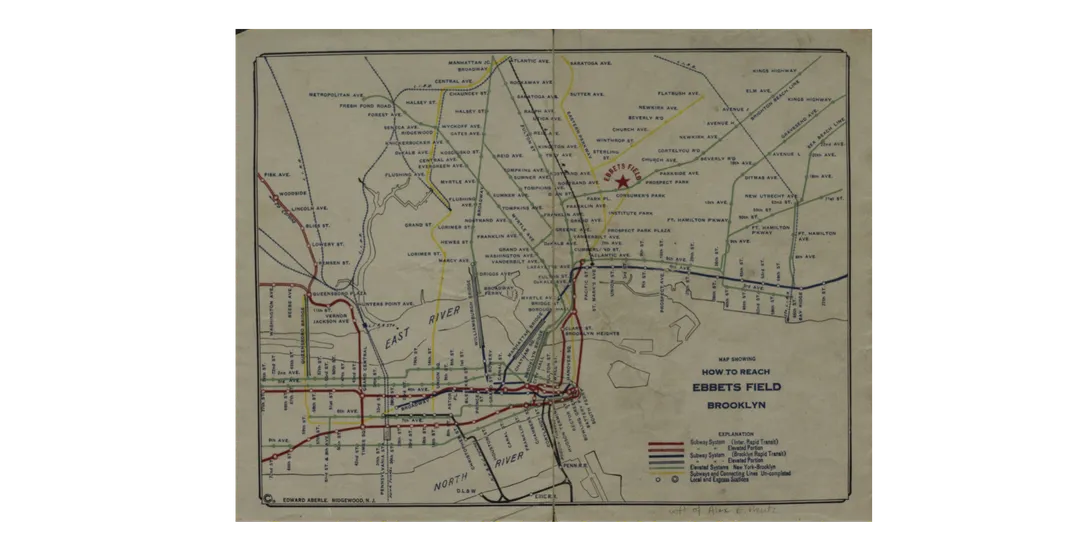
Among the maps featured in the portal are a 2011 guide to smoke-free parks and beaches in the borough; a 1940 map of Brooklyn’s shopping, amusement and business attractions; and a 1919 subway map showing how to reach Ebbets Field.
A more morbid offering is an 1809 “Map of the sickly Neighbourhood of Brooklyne,” which includes numbered plots and tallies of yellow fever deaths in the area that now makes up Brooklyn’s Dumbo neighborhood, per Brownstoner.
As Sarah Bahr points out for the New York Times, people living in Brooklyn can filter the maps by neighborhood to see what the land outside their apartment complex looked like in centuries past. The collection includes aerial maps, nautical maps, topological surveys of the area, and transit guides (including a 1961 New York City subway map and a draft of Frederick Law Olmsted’s original vision for Prospect Park).
“It’s [ultimately] a place for the curious,” Schreiner tells Curbed. “Anyone can visit and take a journey.”
/https://tf-cmsv2-smithsonianmag-media.s3.amazonaws.com/accounts/headshot/nora.png)